🔍 Looking to assess wildfire aftermath more effectively?
Burnt Areas gives you science-backed, satellite-based insights to evaluate fire damage, prioritize recovery, and strengthen future resilience. It’s a powerful tool for anyone working in wildfire response, forestry, or land management.
In this article, we'll cover:
- What are Burnt Areas
- How Burnt Areas are calculated
- Where to find them in WFS
What are Burnt Areas?
Burnt Areas are regions affected by wildfires, identified through satellite-based remote sensing. With automated detection and mapping, you get timely insights to support post-fire assessment. This data helps you understand the fire’s impact, evaluate recovery needs, and plan future mitigation efforts.
How Are Burnt Areas Calculated?
OroraTech’s system utilizes high-resolution multi-spectral imagery from Sentinel-2A/B and Landsat-8/9 satellites to assess burnt areas. The calculation process involves:
-
Pre- and Post-Fire Image Analysis: The system compares satellite images taken before and after a fire event to detect significant spectral differences that indicate burnt regions.
-
Cluster Confidence Assessment: Only burnt areas with a confidence level of 0.4 or higher are mapped, while those below 0.2 are filtered out to maintain accuracy.
-
Advanced Image Processing: Additional masks are applied to minimize false detections caused by snow or other non-fire-related landscape changes.
-
Update Frequency: If cloud-free imagery is available, burnt area data updates every two to three days, ensuring users have access to the latest information.
-
Severity Estimation: Each burnt area is assigned a severity index, which is calculated based on spectral separability from the surrounding environment and spatial relationships with related fire clusters.
For optimal accuracy, we recommend waiting up to 30 days after an incident to allow multiple satellite overpasses, ensuring better imagery and more precise insights.
Where to Find Burnt Areas in WFS
The Burnt Areas feature is available as part of OroraTech’s Advanced Analytics package. Users can access burnt area information via:
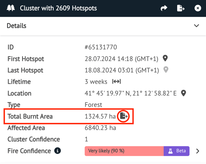
1. Cluster Details Menu
When selecting a Cluster, burnt area details will be displayed alongside other fire-related information.
You can directly export Burnt Scar files in GeoJSON or KML from the highlighted icon.
Data provided includes:
- Burnt area outlines
- Severity level
- Estimated total burnt area
- Before-and-after satellite imagery
- Direct link to the associated cluster
2. Map Interface
Burnt areas are displayed as overlays on the map for easy visualization.
.png?width=513&height=393&name=image%20(12).png)
To view and adjust burn severity on the map:
-
Go to Layers → Fires → Burnt Area
-
Click the settings icon next to High Resolution
-
Use the opacity slider to adjust how prominently the layer appears
-
Use the “Show Severity Levels” checkbox to toggle the severity shading on or off
Optional: Uncheck the Active Fire layer for a clearer view of burn severity zones
💡 Tip: Adjusting these settings can help tailor the map to your needs.

-
Clicking on a burnt area will open a detailed information window with relevant data and imagery.
.gif?width=603&height=282&name=ezgif.com-speed%20(1).gif)
🔓 Unlock Burnt Areas for deeper post-fire insights. Contact our support team to enable it today: support@ororatech.com