- The workflow will have a template to fill out (download it here⬇️)
- Send the template to either your contact person, or to support@ororatech.com
If you have red the Article Set Up Monitored Areas & Sub-Areas Yourself and if:
- you encounter problems during the upload
- you have many areas to upload
- you need to handle buffering for several monitored areas that overlap
the Customer Success team can upload your Monitored areas for you - including buffers, format checks and notification settings.
What we need from you:
- Geodata file(s)
- Acceptable formats: .geojson or .shp + all necessary shapefile components
- Sub-Areas (file properties) as rows, no null geometries!
- Max file size: 100 MB per area
- Filled out Template
- Download Template
- Fill both sheets (Fill out both sheets ("Monitored Area" and "User Selection")


- We recommend to have no more then 5 separate monitored areas.
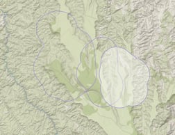
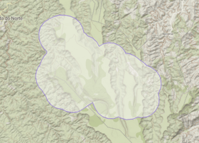
- If separate monitored areas are spatially too close together or intersecting after the buffering (left image), please merge them into one file before sending them (right image).
- In case of already existing Monitored areas, please decide if new areas should complement existing areas or replace them.
Data Format
- Possible file formats: Geojson(.geojson) and Shapefile( .shp, .dbf, .prj, .shx)
- Several sub-areas can be included as a row in the file
- Unified coordinate system for all files (e.g. EPSG 4326, or local coordinate system)
- Attribute table with id column or name column, no null values!
- Other values/columns for subarea properties (region name, area, land cover class)
- File naming and attributes without special characters like mutated vowel (ê, ã, é, ñ )
- File naming and folders without spaces, instead use underscore
- File size per Monitored Area can not exceed 100 megabyte
- Features need to be valid polygons and not null (check validity!)
-
Have a maximum number of subareas per monitored area no larger than 2000. If
more subareas are needed, additional costs might be incurred due to increased
operational effort.
Structure of the Monitored Area
Please fill out this Template for answering the following questions in the first sheet "Fill out Monitored Area":
- Buffer for each MA in kilometers
- If and which Monitored Areas are shared throughout the organization?
- Are the new monitored areas replacing the old areas or are these additional areas?
User structure
Please fill out the second sheet of the template "User selection and notifications"
- Please provide a list of each user who should get access to the platform or already has access (including name, Email, and phone number for notifications)
- If number is provided, shall notifications be sent via SMS or WhatsApp?
- Specify which user should see/control what zone
- Which user/s should get Admin rights? (remove/edit other users)
After filling out the template, please send it to your responsible Customer Success contact.
Notifications
Different notifications settings are available for Email, WhatsApp and SMS.
Geostationary (GEO) and Low Earth Orbit Satellite detections (LEO):
- Option 1 Default for integration: Only GEO detections until validated by LEO detections, then GEO notifications turn off
- Option 2: Only LEO detection notifications
💡 We recommend using the default option 1. If you still wish to have option 2, please indicate in the attached template.